Best sceneries on provincial highways in China
Writer: Chen Xiaochun | Editor: Stephanie Yang | From: Shenzhen Daily | Updated: 2019-11-18
A+ A- Print
Roadtrips are one of the best ways to see the world from the grassroots level. This time we are taking a look at eight provincial highways perfect for taking a long drive, each with its own distinctive and stunning scenery, where you’ll lose yourself in the surroundings, stumble upon the unexpected and possibly blank on where you’re ultimately headed. Each highway links one beautiful part of the country with another, and at least one is bound to melt your heart, so bring a friend or your family along and hit the road.
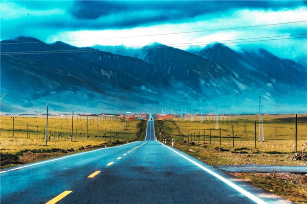
Xinjiang 101 Provincial Highway
This highway was originally built as a national defense highway in the 1960s in preparation for war and natural disasters, a role which has gradually been forgotten in the current era of peace. However, it’s definitely a sacred road for shutterbugs with all the extraordinary scenery that you would expect from Xinjiang including deserts, river valleys, alpine forests, gorges, grassy meadows and snow.
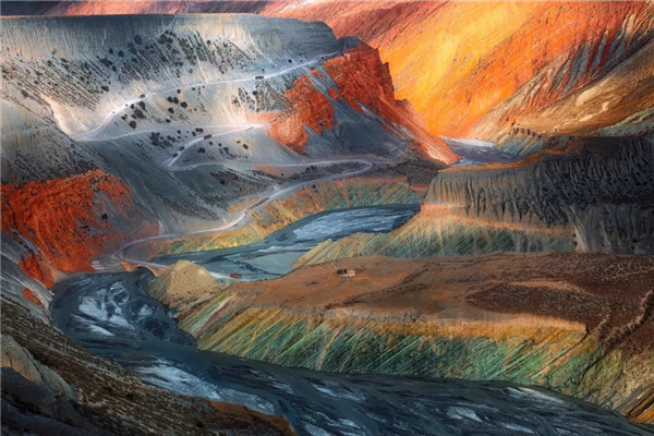
Driving along the 101 Provincial Highway from Liuhuanggou Town toward the west, you will enter the Seven-Color Mountain Valley. Accompanied by this natural beauty, this section between K33 and K36 is the most colorful stretch of the highway. The valley spans 120 kilometers from the east to the west and 12 kilometers from the south to the north. It is located in an earthquake-prone area and has been affected by wind erosion. A jumble of differently colored rocks and loess deposits form magnificent valley scenery. In the horizon, each mountain has a unique shape, borrowing its form from the shapes of such creatures as camels, lions, tigers and monkeys. There are even caves. Sometimes you can see the river water flowing through the valley bottom in a torrential flood.
In different hues of red, orange, yellow, green and cyan, this breathtaking painted landscape is sure to steal your heart once you see it with your own eyes.
The 101 Provincial Highway will also lead you to Ziniquan Town, which is nicknamed “the Alps in Xinjiang.” On the way there, you’ll run into a small picturesque lake, mountains covered in snow, green hills and red earth, which together form a beautiful panorama.
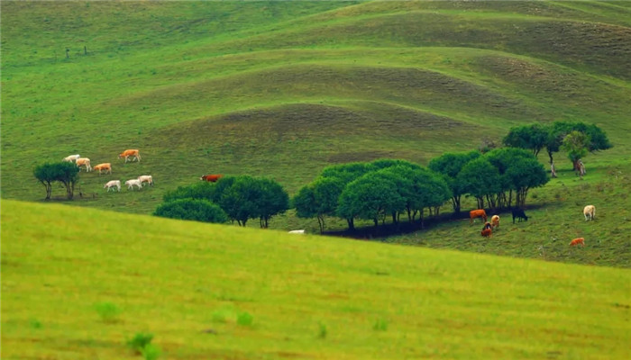
Down the road, you will bump into Lujiao Gulf Meadow, which is one of the best meadows at the northern foot of the Tianshan Mountain. The best part of the meadow starts from the Jingou River Valley and stretches 32 kilometers westwards. The view is super nice, especially in summertime when you can see blue flowers dotting the grasslands and herds of cattle and sheep grazing around.
The meadows are where red deer live and reproduce. Huge numbers of red deer shed their antlers once a year, leaving behind a large number of discarded horns in nearby mountain streams or at the water’s edge at lakes, hence giving rise to the name “Lujiao Gulf Meadow,” which means “deer antler gulf meadow.”

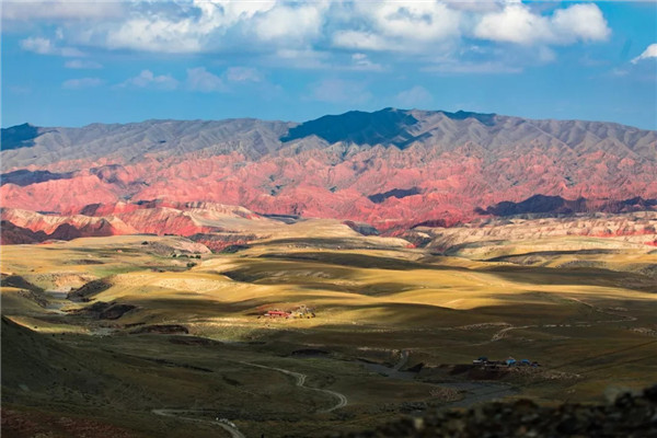
Next on the highway comes the world’s most colorful canyon, the Anjihai Grand Canyon. Also known as the Hongshan (Red Mountain) Grand Canyon, this canyon sitting at the northern foot of the Tianshan Mountains looks like a colorful ribbon carved into the earth. It is an impressive natural wonder comprised of steep cliffs, jagged rocks and vibrantly colored stones.
Keep driving along the provincial highway and you will reach the final destination: Bayingou Pasture. Covering a total area of 3,600 square kilometers and with snow-peaked mountains, green grassland, cattle and sheep, this pasture is a display of magnificent scenery.
The highway starts from the Xishan Mountain Farm in Urumqi in the east and stretches to Kuersale of Duku Highway in the west.
Best time for driving: Late May to June
Note: Along the highway there are many hazardous features like mountains, valleys and bumpy roads. Drive with caution.
244 Provincial Highway in GD
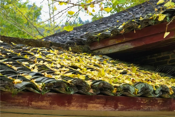
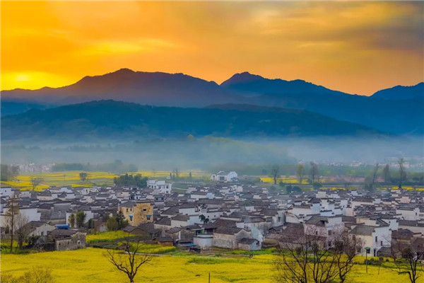
It is widely accepted that the most beautiful part of Guangdong lies in its northern area. The 244 Provincial Highway connects numerous country fields, Hakka round houses, watchtowers, ancient pagodas and farm houses. The highway will lead you to glorious autumn views rarely seen in Guangdong, including golden ginkgo trees and red maple leaves.
Meiguan Ancient Post Road in Shaoguan is one of the stops along the highway. Located on the boundary of Dayu County of Jiangxi Province and Nanxiong City of Shaoguan, Meiguan Ancient Post Road was first built in the Qin (221-206 B.C.) and Han (206 B.C.-A.D. 220) dynasties. In order to promote trade communication, the Tang (618-907) Court constructed the post road, a passage trod by merchants from Jiangxi and Guangdong.
Today, after some 2,000 years, the ancient post road is still kept intact. December or January is the best time to visit Meiguan, as it is the time when the florescence of plum blossoms prevails all over the hills and dales.
You can also indulge yourself in the autumn beauty of Ginkgo Biloba at Maozifeng Forest Farm. Nicknamed “the Jiuzhaigou Valley of North Guangdong,” the forest farm is located in Nanxiong City, Guangdong Province and covers an area of 2,925 hectares.
The Natural oxygen bar Chebaling National Nature Reserve Park is also along the highway. Located between Shixing and Quannan counties, the Chebaling National Nature Reserve Park is an ideal spot for embracing nature. Driving through, you will also reach Yunji Mountain with a spectacular view of a sea of clouds and mountains covered by red maple leaves. The main peak of the mountain rises more than 1,400 meters above sea level.
The highway starts from Zhuji Village in Nanxiong, Shaoguan and reaches Yunji Mountain in Xinfeng County. The route’s length is about 300 kilometers.
Best time for driving: December to January
Inner Mongolia S303 Provincial Highway
The S303 Provincial Highway is not very widely heard of, but it’s a legend among experienced long-distance drivers. The stunning sceneries go hand in hand with the bumpy road, making it an object of both love and hate for most drivers who dare to venture across it.
Galloping along the S303 Provincial Highway, you will see the unique views offered along the gateway of our country on the border between China and Mongolia.
Eventually you will reach a natural treasure called Gongbao Lag Grassland. With clear waters, cute cattle and sheep everywhere, chirping birds and fragrant flowers, simple folk customs, and a pleasant climate, the grassland serves as an ideal place for a summer getaway.
Later, you will pass by the Ujumchin (Ujimqin) Prairie, which is a typical temperate steppe located in the northeastern part of Xiliin (Xilin) Gol League in Inner Mongolia. With an area of more than 70,000 square kilometers, it is much larger than the total area of Hainan Province.
Within the zone are vast stretches of natural grasslands and landscapes of lakes and volcanic remains, the most typical prairie scenery in Inner Mongolia. The prairie is designated as a national biosphere reserve known for its picturesque grassland ecological system.
Keep on driving along the provincial highway, and you will bump into Arxan Mountain, which is no less amazing than that of Switzerland and the heavenly lake on Tuofeng Mountain Range.
The highway starts from Baolage Sumu and reaches Lingdian. The route’s length is about 300 kilometers, 80 kilometers of which is without cell phone signal.
Best time for driving: From June to November
Anhui 218 Provincial Highway
The 218 Provincial Highway in Anhui is only 78 kilometers long, but it connects with 99 percent of the beautiful sceneries in the southern part of the province. Only after driving through this with all the tranquil lake views, small bridges, flowing water, ancient villages and countryside houses can you feel what it’s like to step inside a painting.
Accommodations for spending the night include the motorhome camp of Huangshan Mountain, which is located in Jiaocun Town right at the West Gate of Huangshan Mountain. The large camp covers an area of around 1,000 mu.
Driving on, you will encounter the ancient village of Xidi, which is one of the top 10 most charming villages in China. Xidi Village is home to 224 civil residences that were built in the Ming (1368-1644) and Qing (1644-1911) dynasties. Backed by picturesque hills and towering ancient woods, this village is noted for the harmony of its architecture with the surrounding colorful fields. The residential buildings are mostly black and white.
Hongcun Village is another charming ancient village along the provincial highway. Located at the southwestern foot of Huangshan Mountain, the village is most noted for its overall design that resembles the shape of an ox. The architecture and carvings of the approximately 150 residences dating back to the Ming and Qing dynasties are said to be among the best of their kind in China.
Then you will enter one of the four fairy lands for autumn views in China, Tachuan Village. The autumn scene at Tachuan Village is one of the most picturesque places imaginable with the leaves of its ancient old trees turning red and yellow.
Mukeng Village, hidden among the dense bamboo, is another romantic place that will melt your heart on your roadtrip. It’s the shooting place for the film “Crouching Tiger, Hidden Dragon.”
Best time for driving: March to May and September to November
Shaanxi S212 Provincial Highway
If we say Qinling Mountain is a gift from the nature to Shaanxi, the S212 Provincial Highway is a ribbon wrapping around it that completes the present. Along this route, you can see beautiful sceneries all year long, especially in autumn. People who have driven through it said that you can touch the romantic color once you stretch out your hand.
You will get lost in front of the stunning essence of Baoji, the Taibai Mountain. It is the main peak of China’s famous Qinling Mountain and the highest peak in West China with a height of 3,767 meters above sea level. Taibai means “too white” in Chinese. The name derives from the color of the snow-capped mountain peak. The mountain is bestowed with unique natural geographical conditions, and coupled with its towering momentum and the illusive climate variations.
Along this route, you will also be amazed by the “dragon’s vein” of China’s history and culture: Qinling, the dividing line of southern and northern China. As the Qinling Mountains divide China into north and south, the temperature, climate and geography on each side are also distinctively different.
The rivers to the south of Qinling won’t be frozen in winter, the forests are mainly home to evergreens and broad-leaved trees, and the soil is mostly acidic. The temperature in northern Qinling is below zero degree Celsius in January when the river is frozen, and the forests are dominated by deciduous broad-leaved trees and soil that is rich in calcium.
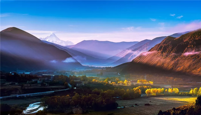
Western Sichuan Small Ring Line
The beauty of Sichuan Province lies in its western part. Western Sichuan Small Ring Line is always described by travel enthusiasts as “paradise for your eyes and hell for your body” due to its stunning sceneries and tough road conditions. If you want to travel through western Sichuan but don’t want to tire yourself out, then Western Sichuan Small Ring Line should be a nice option.
Galloping along this route, you will encounter Mount Siguniang, the “Alps in the East.” Mount Siguniang, meaning “Four Girls Mountain” or “Four Sisters Mountain,” is the highest peak of western China’s Qionglai Mountains. It encompasses four continuous peaks, with the main peak reaching 6,250 meters above sea level.
Later you will find Danba Tibetan Villages, which feature numerous Tibetan-style stockade houses and watchtowers. The watchtowers in Danba vary in height from 16 to 35 meters. They stand in knots on hillsides or alone on the tops of undulating hills.
Driving along the route, you will eventually reach a paradise for shutterbugs: Xinduqiao Town. The peaceful Tibetan town in west Sichuan is a characteristic place to visit and good for photography.
Then you will get lost in the Scenic Spot of Kangding Love Song (Mugecuo), which is endowed with a breathtaking view. Mugecuo is the largest alpine lake among regions located 2,000 meters or higher above sea level in Sichuan. The scenic area is famous for its fantastic springs, alpine lakes, primeval forests, grasslands and snowy mountains.
Best time for driving: May, late October and mid-November
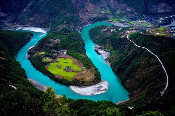
Yunnan Degong Highway
Only 98.2 kilometers long, Degong Highway goes through three rivers and will lead to the sceneries of four different seasons, including snowy mountains, forests, flower fields and villages.
Driving along Degong Highway, you will thrill at a world geographical miracle where you can see three rivers that flow out parallel to each other from the Qinghai-Tibet Plateau to the south but never converge. The three parallel rivers are Jinsha River, Nujiang River and Lancang River. This is the 29th project of the World’s Cultural and Natural Heritage in China, Three Parallel Rivers of Yunnan Protected Areas.
You will also see Biluo Snow Mountain, home to many waterfalls and lakes, hence the nickname of “mountain of tens of thousands of waterfalls and thousands of lakes.”
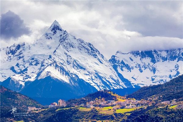
Later, standing in front of Meili Snow Mountain, you will be amazed by its grand and sacred beauty. Known for its views, which are some of the best in Yunnan Province, Meili Snow Mountain boasts numerous snow-clad ridges and peaks, 13 of which exceed 6,000 meters above sea level. The most splendid view is of the Kawagebo Peak, the highest in Yunnan Province at about 6,740 meters. It is still a virgin peak, for no one has ever reached the top.
Keep driving and you will enter a mundane paradise — Bingzhongluo Town — which sits deep in the Nu-jiang Grand Canyon. Reputed as “a Heaven of Peace and Happiness,” it is the most beautiful place in the Nujiang Grand Canyon. Here you will find the Tea Horse Road of Millennium, the roaring Nujiang River running among the steep cliffs and deep valley, splendid temples, tranquil villages, thick forests, and towering snow-capped mountains.
Degong Highway starts from the east bank of the Lancang River in Yunling Village and reaches Shanda Village of Pengdang Township in Gongshan County.
Best time for driving: from June to November
Taihang Sky Road South in Henan Province
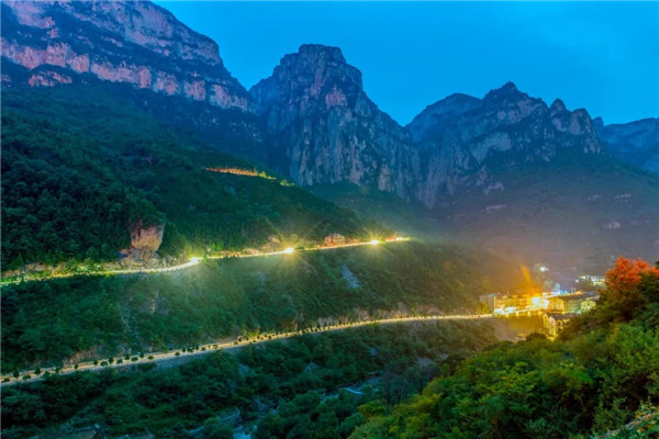
Taihang Mountain is a highlight of Henan Province, with the southern side of Taihang Mountain giving captivating views along Taihang Sky Road.
Traveling along the sky road, you will see the imposing Wanxian Mountain. The scenic area consists of four scenic sites including Guoliang Village, which is known for being a shooting place for many films, the beautifully secluded mountain village of Nanping, the heavenly paradise-on-earth of Luojie Village, and Sanhu Lake, which is revered in Taoism.
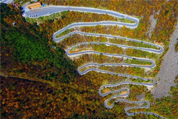
You will experience a surge of adrenaline while driving along the most precipitous road in the world, the hanging highway of Guoliang, and wow at the majesty of the Taihang Grand Canyon, one of “China’s 10 best grand canyons.” In this scenic area, thousands of peaks contending for beauty, strange and unique topography and geomorphology, together with rare animals and plants resources, make the Taihang Grand Canyon one of the most wonderful natural sceneries.
Best time for driving: from June to November