Explore karst wonders

A fisherman casts his net on the Lijiang River. SD-Agencies
Guangxi Zhuang Autonomous Region, located in South China and bordering Guangdong Province on the east, Yunnan Province on the west and Vietnam on the southwest, is among the country’s most favored tourist destinations for its abundant karst landforms. As China’s road network continues to expand, self-driving tours to explore these unique wonders are becoming easier than ever before. Here we present for you three self-driving routes to explore what this land has to offer.
Northern Guangxi route
Meandering more than 160 kilometers from Guilin City’s Xing’an County to Pingle County, the Lijiang River and the karst peaks and rocks on its banks are a must-see for anyone visiting Guangxi for sightseeing purposes. Our first recommended self-driving route starts from Yangshuo County and includes along-the-river stops at Xingping Ancient Town, Daxu Ancient Town and Guilin’s city center before arriving at the final stop of Mao’er Mountain.
Drive northward along Provincial Highway 202 from the county center of Yangshuo for around 30 kilometers and you will arrive at Xingping Ancient Town, a town with more than 1,700 years of history.
Small as it is, the town is home to more than 20 scenic spots including Laozhai Mountain, the top of which is a perfect spot for a panoramic view of the Lijiang River and karst peaks of various shapes and sizes on its banks. It is also an ideal spot for a distant look at the famous Jiumahuashan (Nine Horses Fresco Hill) attraction, a mountain whose mottled cliff facing the river resembles a painting of nine horses in different poses.
Continue to drive along Provincial Highway 202 for another 50 kilometers to the next stop, Daxu Ancient Town. Just as its name indicates (“Daxu” in Chinese means a big marketplace), the town with 13 docks was once famous for its prosperous trade fairs. Today’s Daxu Ancient Town, with well-preserved ancient buildings and old streets, is a good place for an experience of the ancient Chinese way of living. You are also recommended to have a distant look at the Mopan (Millstone) Mountain, which derives its name from its millstone-like appearance.
The trip continues as you drive northwesterly toward the city center of Guilin. This is where some of Guangxi’s most iconic karst scenic spots are located, such as Xiangbi (Elephant Trunk) Mountain and Ludi (Reed Flute) Cave. Also to be found here is the 600-year-old Jingjiang Palace, which over a span of around 280 years served as the residence of 14 Ming Dynasty (1368-1644) princes. On the cliff of Duxiu Peak inside the palace you will find inscriptions by literati dating back centuries, the most famous among which being “桂林山水甲天下” (East or west, Guilin is the best) by Southern Song (1127-1279) scholar Wang Zhenggong.
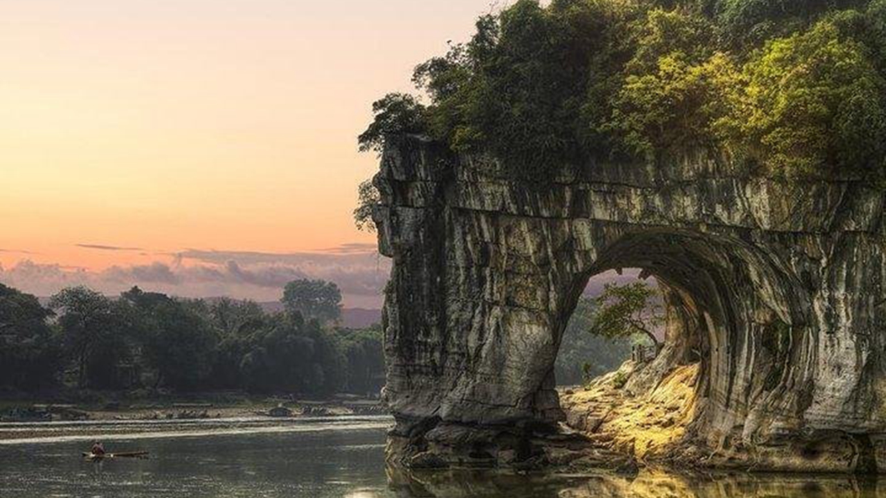
The iconic Xiangbi Mountain is in the city center of Guilin.
If you feel like exploring the source of the Lijiang River after seeing so many natural marvels alongside the river, then the final stop of this trip is Mao’er (Cat) Mountain in Xing’an County, which is about a 110-km drive from the Guilin city center. Take some time for a walk along the Lijiangyuan (Source of Lijiang River) Grand Canyon at the foot of the mountain — there the fresh air, clear water and fragrance of bamboo forests will provide you a sanctuary for peace of mind.
Western Guangxi route
If you are seeking even wilder-looking karst landforms, then you may opt for a trip to the mountainous area in the northern part of Hechi and Baise cities in western Guangxi. Starting from the autonomous region’s capital city Nanning and ending at Baise’s Leye County with stops at Hechi’s Qibainong Township, Shuijinggong Cave and Sanmenhai Ecological Tourist Zone, this self-driving route features clusters of karst peaks, solution caves, sinking rivers and sinkholes.
Sanmenhai Ecological Tourism Zone.
Around 190 kilometers from the bustling city of Nanning, Qibainong Township is home to the Qibainong National Geological Park which boasts thousands of karst peaks and rocks, over 1,300 karst depressions and many more typical karst landforms. A drive through Qibainong is like a journey through rough seas — as steep rocks and cliffs keep passing by the car window, you just can’t help but be awed by the power of nature.
Continue to drive down National Highway 323 for around 60 kilometers and you will arrive at Bama, a Yao autonomous county widely known for the longevity of its residents. A scenic spot not to be missed here is the Shuijinggong (Crystal Palace) Cave. Rated by the Chinese National Geographic magazine as one of China’s seven most beautiful karst caves, the cave features stalactite and stalagmite formations in white color. Glittering in the light, these crystal-like natural decorations have made the cave a wonderland on Earth.
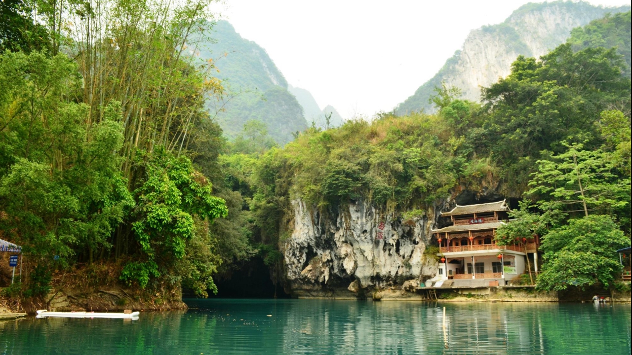
Bid farewell to Bama and after another 70 kilometers of driving, the Sanmenhai Ecological Tourist Zone is waving hello. This scenic spot is well noted for the seven skylights formed out of the collapse of solution cave roofs as well as the river that flows through it. The Poxin River is the longest sinking river in Guangxi. So, don’t forget to take a boat trip into the caves for some breathtaking views.
More than 130 kilometers away from Sanmenhai, Leye County, the final stop of the trip, is hailed as “the city of sinkholes” for the large number of karst sinkholes, especially the recently discovered giant sinkholes. In addition to visiting some of these sinkholes, you will also enjoy a visit to the Luomei Lianhua (Lotus) Cave, which abounds in lotus flower- and lotus seed-shaped stalagmites.