Innovation and tech park on border
Writer:
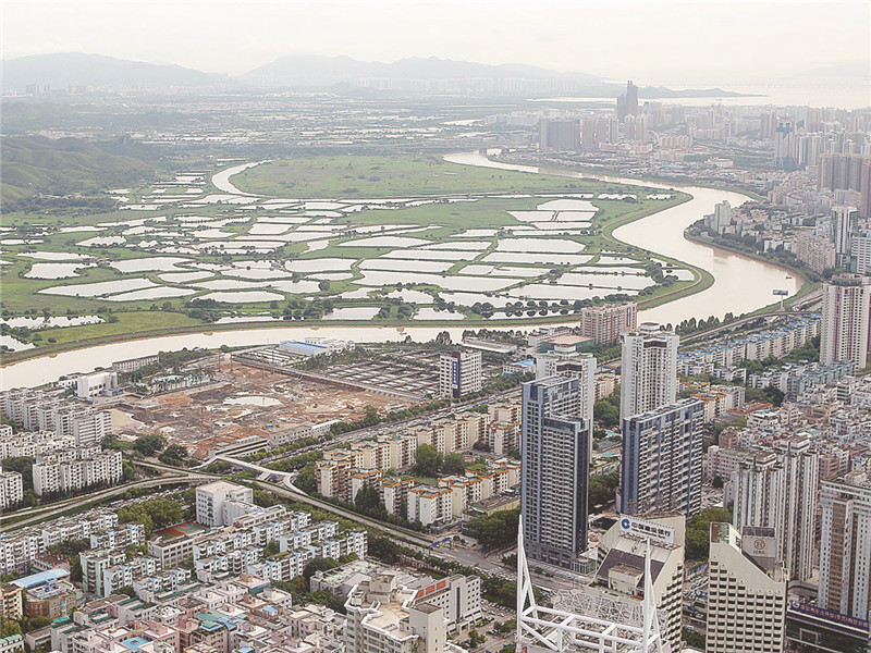
A view of the Lok Ma Chau Loop area (the undeveloped area in the picture) in this file photo taken in 2010. SD-Agencies
Hong Kong and Shenzhen signed a memorandum of understanding related to the development of Lok Ma Chau Loop, which totals 87 hectares, into an innovation and technology park Jan. 2.
Former Hong Kong Chief Executive Leung Chun-ying said in January that the size of the park would be four times that of the Hong Kong Science Park and would be “Hong Kong’s largest innovation and technology platform ever.”
“It has great and unique meaning to develop innovation and technology in the Loop. The Loop is only a river away from Shenzhen — that is, within ‘one country,’ next to Shenzhen and within the ‘Hong Kong system,’” Leung said. “It has the benefits and convenience of the ‘one country, two systems.’”
Hong Kong’s boundaries were defined by the Basic Law issued in 1990, but the river loop was a piece of new land that fell into Hong Kong’s territory after the Shenzhen River was straightened in 1997.
The land was disputed until the State Council in 1997 issued a directive clarifying that the Loop would be Hong Kong territory.
Former Chief Executive Donald Tsang announced a partnership with Shenzhen in his 2007-08 policy address to “jointly explore the feasibility of developing Lok Ma Chau Loop for our mutual benefit.”
Then, in December 2007, the Hong Kong-Shenzhen Joint Task Force on Boundary District Development was formed to coordinate, liaise and steer the planning and development of the land in the boundary district.
Hong Kong’s Town Planning Board announced June 9 the publication of a new draft outlining the zoning plan for the Lok Ma Chau Loop area.
The development of Lok Ma Chau Loop could provide an important synergy and give impetus to the adjacent areas, including the Kwu Tung North New Development Area, commercial areas in Shenzhen, and the territory as a whole, to provide supporting facilities and services, talents, customers and markets.
The development could also foster a tech-ecosystem for high-technology and knowledge-based industries in the northeastern part of Hong Kong. After being fully developed, the Lok Ma Chau Loop area will be able to accommodate a working/student population in the range of 50,000 to 53,000.
The planning scheme area of the draft Lok Ma Chau Loop OZP, covering about 104 hectares, is bordered by the bank of the Shenzhen River in the northwest, the fishponds of Hoo Hok Wai in the northeast, Lok Ma Chau and Tai Law Hau in the south, and the Lok Ma Chau Control Point, the Lok Ma Chau Spur Line Control Point and the Mai Po Nature Reserve to the southwest. To the north, across the Shenzhen River, is the Futian commercial area and Huanggang Checkpoint of Shenzhen.
About 1.23 hectares are zoned “Commercial” and will be used primarily for offices, shops, services, entertainment venues, eateries and hotels, functioning mainly as a commercial/shopping center to serve the needs of Lok Ma Chau Loop.
About 3.95 hectares are zoned “Government, Institution or Community” and intended primarily for the provision of government, institution and community facilities serving the needs of Lok Ma Chau Loop and/or the wider district, region or territory.
About 18.18 hectares are zoned “Open Space” for the provision of open-air public space for active and passive recreational uses.
Land designated for specific uses, such as “Research and Development, Education, and Cultural and Creative Industries,” “Ecological Area” and “Sewage Treatment Works,” is zoned “Other Specified Uses” and totals about 53.49 hectares.
(SD-Agencies)